Explore detailed Ancient Egyptian maps showing Upper and Lower Egypt, major cities, pyramids, temples, trade routes, nomes, and the empire through history.
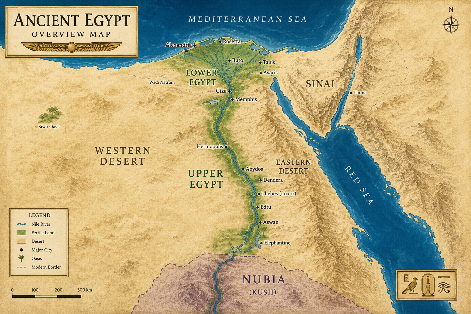
Almost every ancient Egyptian settlement developed along the Nile because it was the country’s only reliable source of fresh water in an otherwise arid desert. The river shaped every aspect of Egyptian life, from agriculture and transportation to religion and politics. Here are the main reasons why:
Fresh Water
Ancient Egypt received very little rainfall, and much of the surrounding landscape was barren desert. The Nile provided a dependable supply of drinking water for people, livestock, and crops. Without the river, permanent settlements would have been nearly impossible across most of Egypt.
Fertile Farmland
Each summer, the Nile overflowed its banks, depositing a layer of nutrient-rich black silt across the floodplain. This fertile soil allowed Egyptians to grow crops such as wheat, barley, flax, vegetables, and fruit, supporting one of the ancient world’s largest and longest-lasting civilizations.
The Egyptians even called this fertile land Kemet, meaning “the Black Land,” in reference to the dark, fertile soil left behind by the floods. The surrounding deserts were known as Deshret, or “the Red Land.”
Natural Transportation Highway
The Nile functioned as Ancient Egypt’s main highway. Boats could travel downstream with the current and sail upstream using the prevailing northward winds. This made it possible to transport people, grain, stone, troops, and trade goods efficiently across hundreds of miles.
Because river travel was much faster than crossing the desert, nearly every major city, temple, and royal residence was established close to the Nile.
Trade and Communication
The river connected Egypt’s major population centers, making it easier for merchants to exchange goods and for pharaohs to administer their kingdom. Trade routes along the Nile linked communities from the Mediterranean coast to Nubia, bringing gold, ivory, incense, timber, copper, and luxury goods into Egypt.
Food and Natural Resources
The Nile supported abundant wildlife that provided food and raw materials. Egyptians fished for species such as Nile perch and catfish, hunted waterfowl in the marshes, and harvested papyrus to make boats, baskets, mats, rope, and the writing material that bears its name.
Defense
The deserts on either side of the Nile acted as natural barriers against invasion, while concentrating settlements within the narrow river valley. This allowed Egyptian rulers to govern a relatively compact, connected population despite the country’s great length.
Religious Importance
The Nile was considered a divine gift that sustained all life. Its annual inundation was associated with renewal and rebirth, and the river was closely connected with deities such as Hapi, the god of the annual flood, and Osiris, whose death and resurrection symbolized the cycle of fertility and new life. Many temples were built along the river, reinforcing its central role in Egyptian religion.
As a result, more than 95% of Egypt’s population lived within a few miles of the Nile Valley and Delta. Even today, the same pattern remains largely unchanged. Viewed from space, Egypt appears as a narrow ribbon of green winding through vast expanses of desert, highlighting just how completely the Nile determined where people could live.
This close relationship between the river and civilization led the Greek historian Herodotus to famously describe Egypt as “the gift of the Nile,” a phrase that still captures the river’s importance more than 2,000 years later.
Map of Upper and Lower Egypt
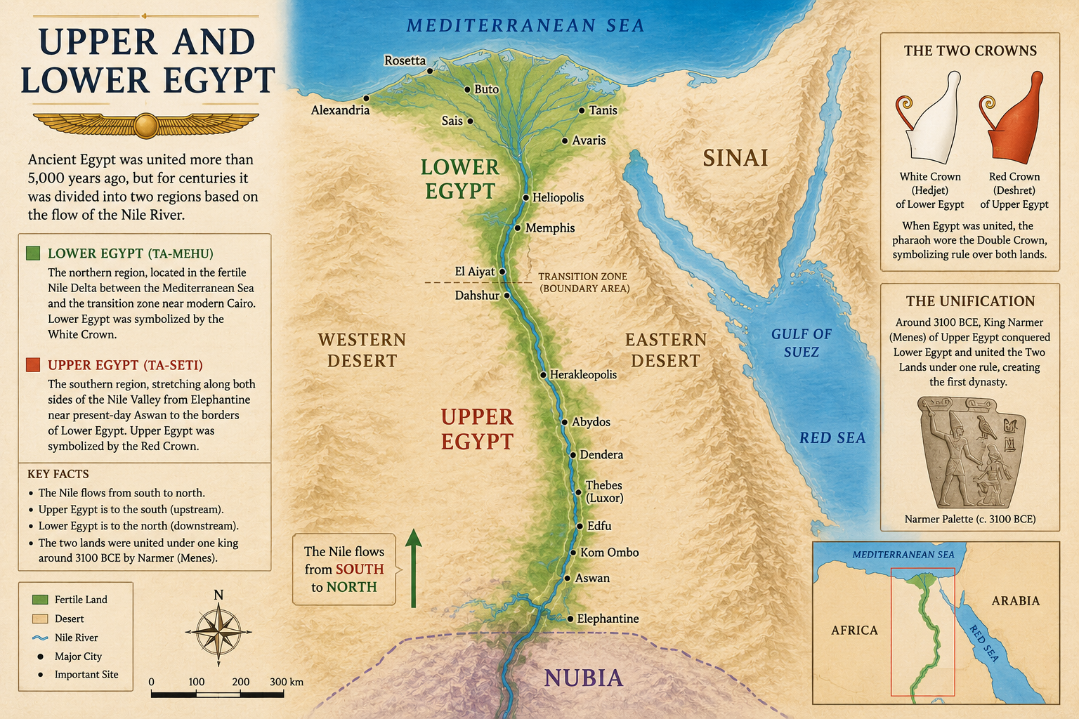
One of the first things that surprises many people about Ancient Egypt is that Upper Egypt is actually in the south, while Lower Egypt is in the north. This seemingly backwards naming system has nothing to do with compass directions. Instead, it follows the course of the Nile River, which flows from the highlands of East Africa northward into the Mediterranean Sea. Since the river flows downhill, the southern region was known as Upper Egypt, while the northern Nile Delta became Lower Egypt.
For thousands of years before Egypt became a unified kingdom, these two regions developed as separate political and cultural entities. Each had its own rulers, traditions, religious centers, and royal symbols. Although they shared the same river, Upper and Lower Egypt often competed for power before eventually being united under a single king.
Upper Egypt
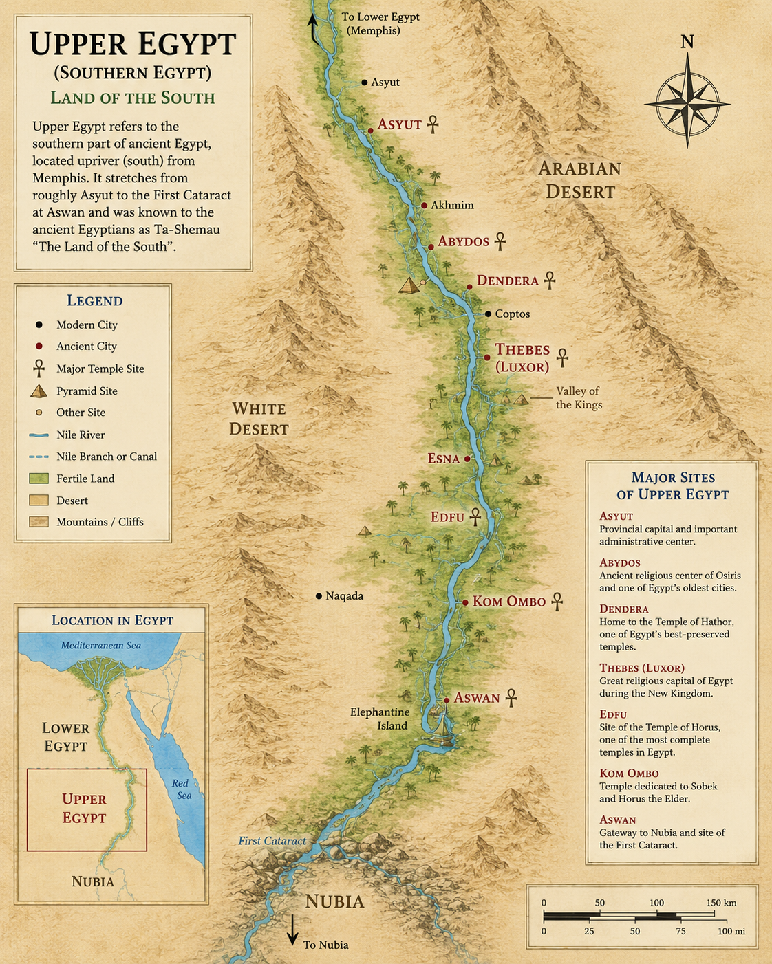
Upper Egypt occupied the long, narrow Nile Valley stretching from the First Cataract near modern-day Aswan north to the area around Memphis. Unlike the broad Delta, this region was confined between steep desert cliffs, creating a fertile ribbon of farmland that hugged both sides of the Nile.
Many of Egypt’s greatest religious and political centers were located here, including Thebes (Luxor), Abydos, Hierakonpolis, and Elephantine. During the New Kingdom, Thebes became the capital of Egypt and home to magnificent temples such as Karnak and Luxor.
Upper Egypt was represented by the White Crown, known to the Egyptians as the Hedjet. This tall, conical crown symbolized the authority of the kings who ruled the southern kingdom before Egypt was united.
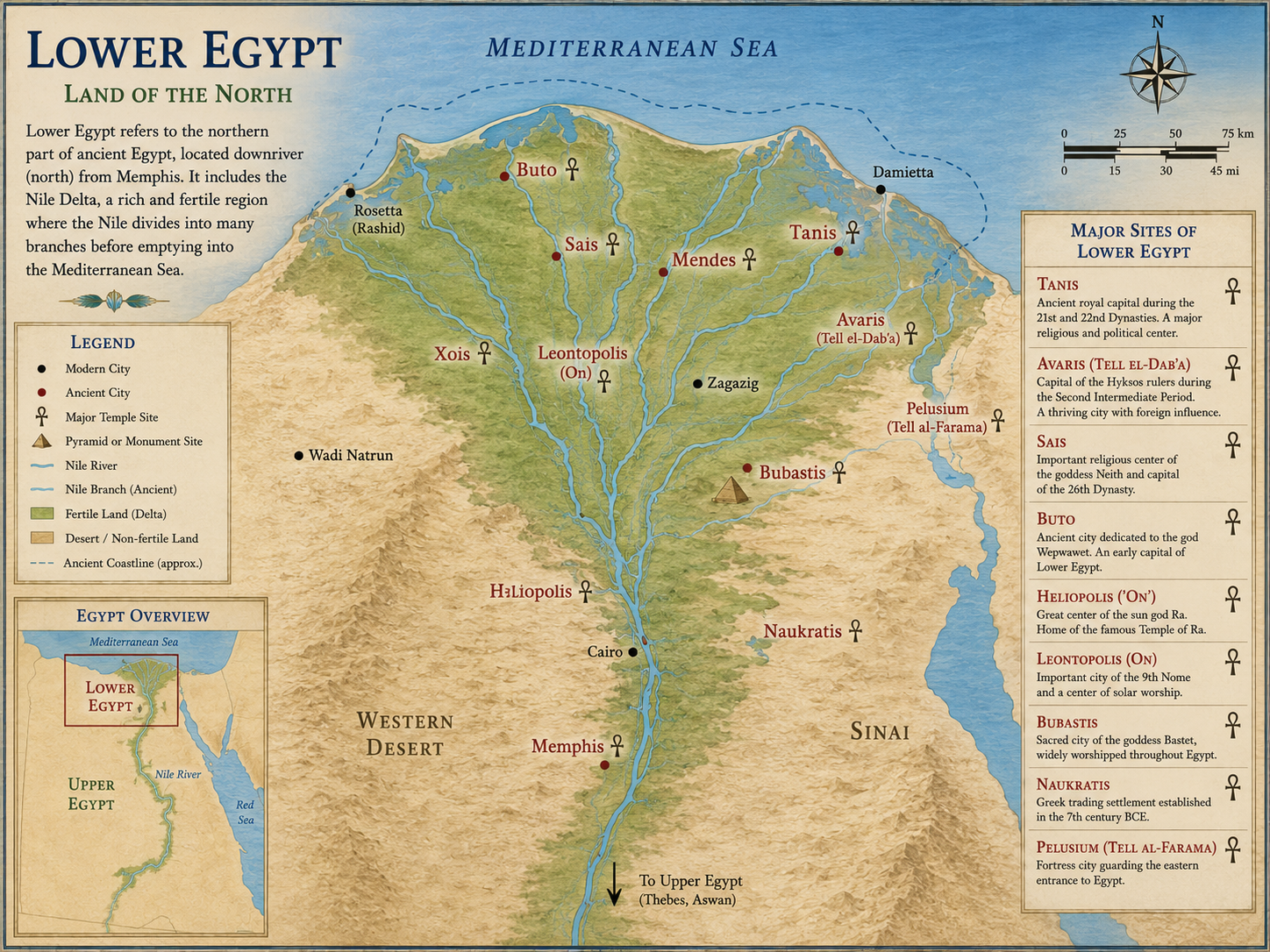
Lower Egypt
Lower Egypt occupied the vast Nile Delta where the river divided into numerous branches before emptying into the Mediterranean Sea. This region consisted of rich wetlands, marshes, fertile farmland, and numerous waterways that made it one of the most productive agricultural areas in the ancient world.
Important cities in Lower Egypt included Memphis, Heliopolis, Sais, Buto, Tanis, and later Alexandria during the Ptolemaic Period. Because it sat at the crossroads of Africa, Asia, and the Mediterranean, Lower Egypt became a center for international trade and cultural exchange.
Lower Egypt was symbolized by the Red Crown, called the Deshret. The distinctive crown featured a tall back projection and a curled spiral at the front, representing the rulers of the northern kingdom.
The Importance of the Nile Delta
The Nile Delta was one of Ancient Egypt’s greatest natural assets. Every year, the Nile deposited rich layers of black silt across the Delta, creating exceptionally fertile farmland capable of producing enormous harvests of wheat, barley, flax, vegetables, and fruit.
The Delta also served as Egypt’s gateway to the Mediterranean world. Ships traveling between Egypt and regions such as the Levant, Cyprus, Crete, and later Greece often entered through the Delta’s waterways. As a result, Lower Egypt became a thriving hub of trade, diplomacy, and military activity.
The abundance of food produced in the Delta helped support Egypt’s growing population and provided the agricultural surplus that funded monumental building projects, military campaigns, and temple construction for centuries.
Life in the Nile Valley
Outside the Nile Valley and Delta, Egypt was almost entirely desert. Rainfall was extremely rare, and permanent settlements away from the river were uncommon except at a handful of oases.
The Nile transformed this harsh environment into a narrow corridor of life. Its annual floods deposited fertile black silt along the floodplain, allowing farmers to cultivate crops year after year. Villages, temples, royal palaces, and entire cities clustered close to the river because it supplied fresh water, fertile land, transportation, fish, papyrus, and trade routes.
The Nile also functioned as Egypt’s main highway. Boats drifted north with the current and sailed south using the prevailing winds, making travel remarkably efficient. This natural transportation network connected communities across more than 600 miles of river valley and helped unify one of history’s longest-lasting civilizations.
The Unification of Egypt
Around 3100 BC, the separate kingdoms of Upper and Lower Egypt were united into a single nation under the rule of King Narmer, who is often identified with the legendary ruler Menes in later historical traditions. Narmer’s victory marked the beginning of Egypt’s First Dynasty and the Early Dynastic Period.
One of the most important artifacts commemorating this event is the Narmer Palette, a ceremonial stone carving discovered at Hierakonpolis. On one side, Narmer is shown wearing the White Crown of Upper Egypt, while on the other he wears the Red Crown of Lower Egypt. Together, these scenes symbolize his authority over both lands.
Following the unification, Egyptian kings adopted the Double Crown, known as the Pschent, which combined the White Crown of Upper Egypt with the Red Crown of Lower Egypt into a single royal headdress. The Double Crown became one of the most recognizable symbols of the pharaoh’s authority and represented the king’s sacred duty to rule and protect “The Two Lands.”
Why the Two Lands Still Mattered
Although Egypt became a unified kingdom, the distinction between Upper and Lower Egypt never disappeared. Official inscriptions frequently referred to the country as The Two Lands, emphasizing the importance of maintaining harmony between its two historic regions.
Pharaohs often included titles such as “King of Upper and Lower Egypt” in their royal names, and many ceremonies reinforced the idea that both regions remained united under a single divine ruler. Even thousands of years after Narmer’s reign, the concepts of Upper and Lower Egypt continued to shape Egyptian government, religion, art, and royal ideology.
Understanding the relationship between these two regions provides the foundation for understanding Ancient Egyptian civilization itself. Nearly every major event in Egyptian history, from the rise of the pharaohs to the construction of the pyramids and the growth of Thebes, was influenced by the unique geography of the Nile Valley and the enduring unity of the Two Lands.
Ancient Egypt Cities Map
A map of Ancient Egypt is not complete without its most important cities. While the Nile River connected the country from south to north, each major city had its own role in Egyptian history. Some were royal capitals, others were religious centers, burial grounds, trading hubs, or military strongholds.
Many of these cities rose and fell in importance depending on the period. Memphis dominated early Egyptian history, Thebes became the great religious capital of the New Kingdom, Alexandria became the intellectual center of Ptolemaic Egypt, and cities in the Delta such as Avaris, Tanis, and Pi-Ramesses played major roles in Egypt’s relationship with the eastern Mediterranean world.
Memphis
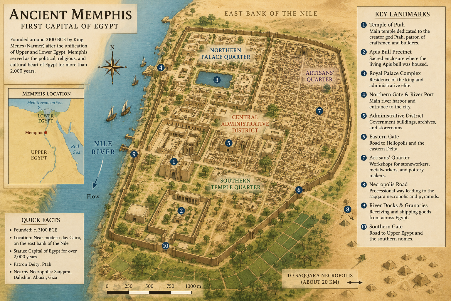
Memphis was one of the most important cities in Ancient Egypt and served as an early capital after the unification of Upper and Lower Egypt. Located near the point where the Nile Valley meets the Delta, Memphis was perfectly positioned to control both northern and southern Egypt. This made it an ideal administrative center for the newly unified kingdom.
The city was closely associated with the god Ptah, a creator deity and patron of craftsmen. Memphis remained important for thousands of years, even when later pharaohs ruled from other cities. Its nearby necropolises, including Saqqara, Giza, Abusir, and Dahshur, became some of the most famous burial landscapes in Egyptian history.
Thebes
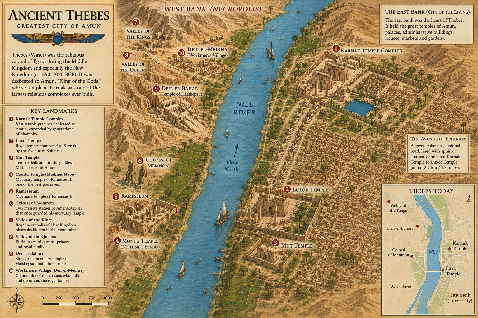
Thebes, located near modern Luxor, became one of the greatest religious and political centers of Ancient Egypt. It rose to special prominence during the Middle Kingdom and reached the height of its power during the New Kingdom, when many pharaohs ruled from or strongly favored the city.
Thebes was sacred to Amun, whose temple complex at Karnak became one of the largest religious sites in the ancient world. Across the Nile on the west bank lay the Theban necropolis, including the Valley of the Kings, the Valley of the Queens, and mortuary temples built for rulers such as Hatshepsut and Ramesses II.
Alexandria
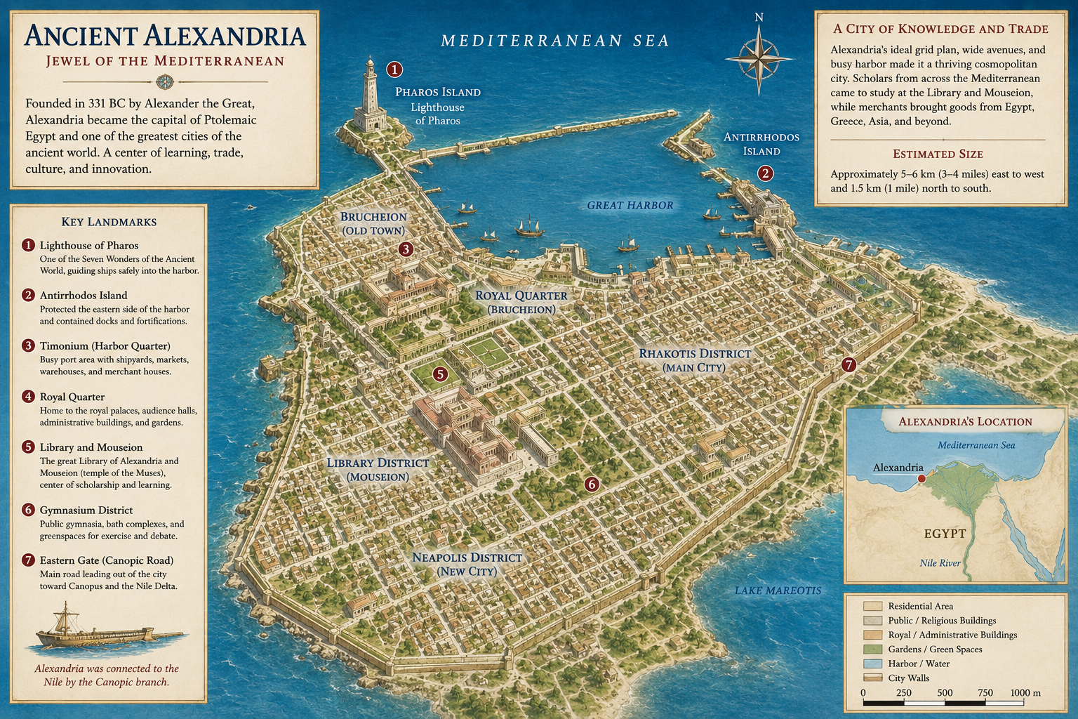
Alexandria was founded by Alexander the Great in 331 BC and became the capital of Egypt during the Ptolemaic Period. Unlike older Egyptian cities, Alexandria was built as a Greek-style Mediterranean city, blending Egyptian, Greek, and later Roman influences.
The city became famous for its Great Library, its scholarly community, and the Lighthouse of Alexandria, one of the Seven Wonders of the Ancient World. Under the Ptolemies, including Cleopatra VII, Alexandria became Egypt’s political capital and one of the most important ports in the Mediterranean.
Abydos
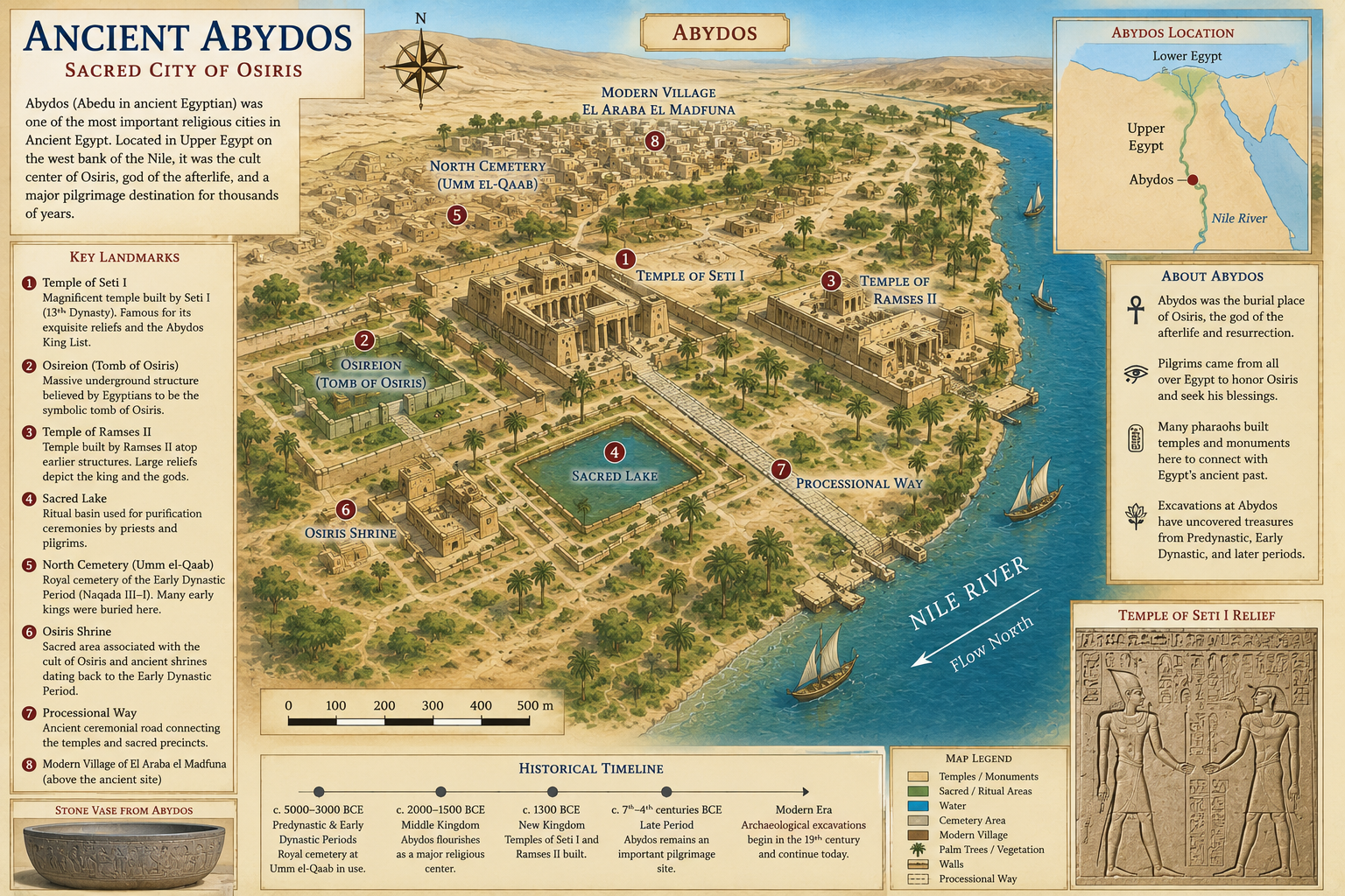
Abydos was one of the oldest and most sacred cities in Ancient Egypt. Located in Upper Egypt, it was strongly associated with Osiris, the god of the afterlife, resurrection, and rebirth. Egyptians believed Abydos was connected to the burial place of Osiris, making it one of the most important pilgrimage sites in the country.
Many early kings were buried near Abydos, and later pharaohs built temples and monuments there to connect themselves with Egypt’s ancient past. The Temple of Seti I at Abydos is especially famous for its beautiful reliefs and the Abydos King List, which records the names of earlier Egyptian rulers.
Amarna
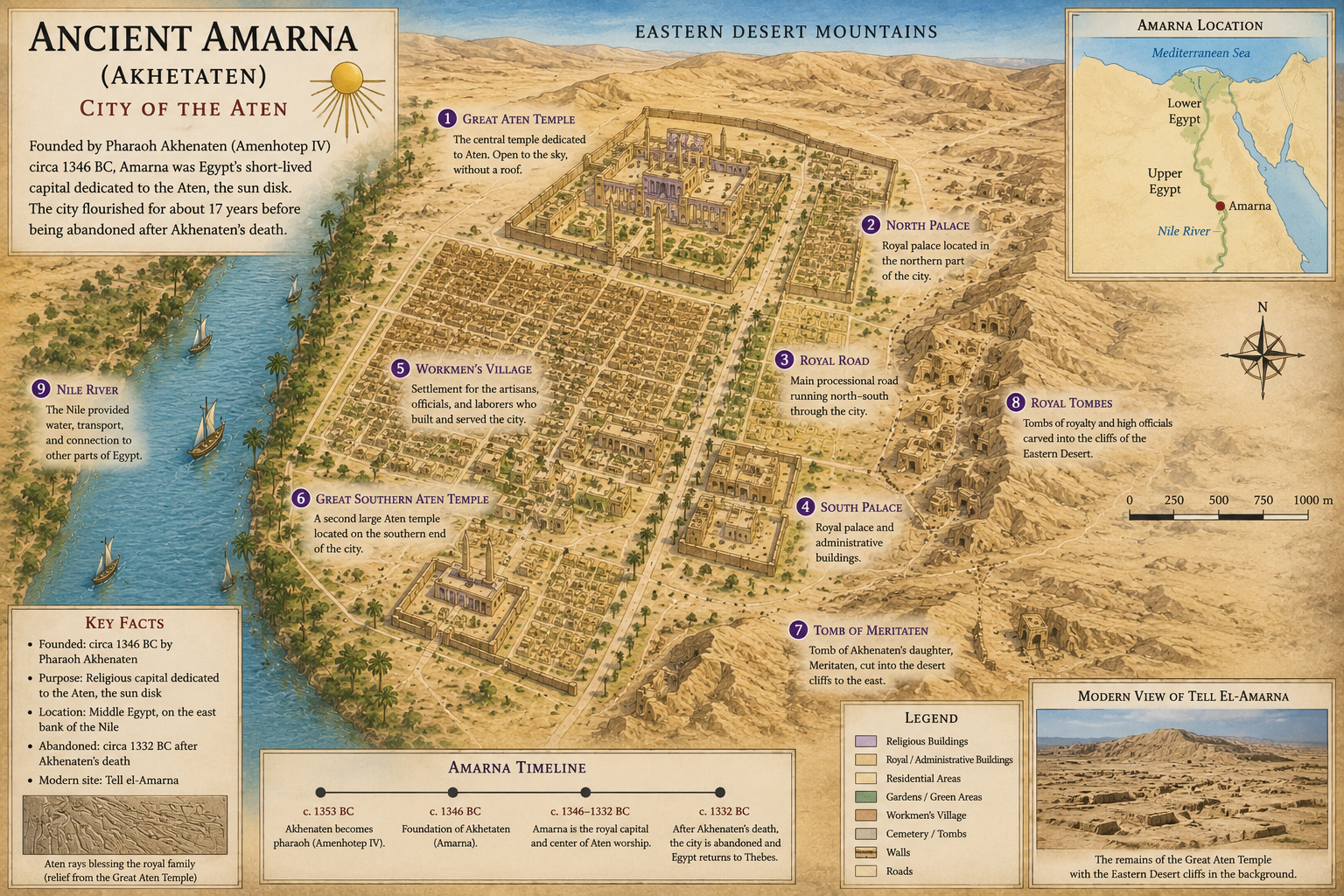
Amarna, ancient Akhetaten, was the short-lived capital built by Pharaoh Akhenaten during the 18th Dynasty. Akhenaten created the city as the center of his religious revolution, which focused worship on the Aten, the sun disk.
Unlike cities that developed gradually over centuries, Amarna was planned and built quickly in the desert between Memphis and Thebes. After Akhenaten’s death, the city was abandoned, and Egypt returned to its traditional religious practices. Today, Amarna is one of the most important archaeological sites for understanding daily life, royal art, and religion during this unusual period.
Giza
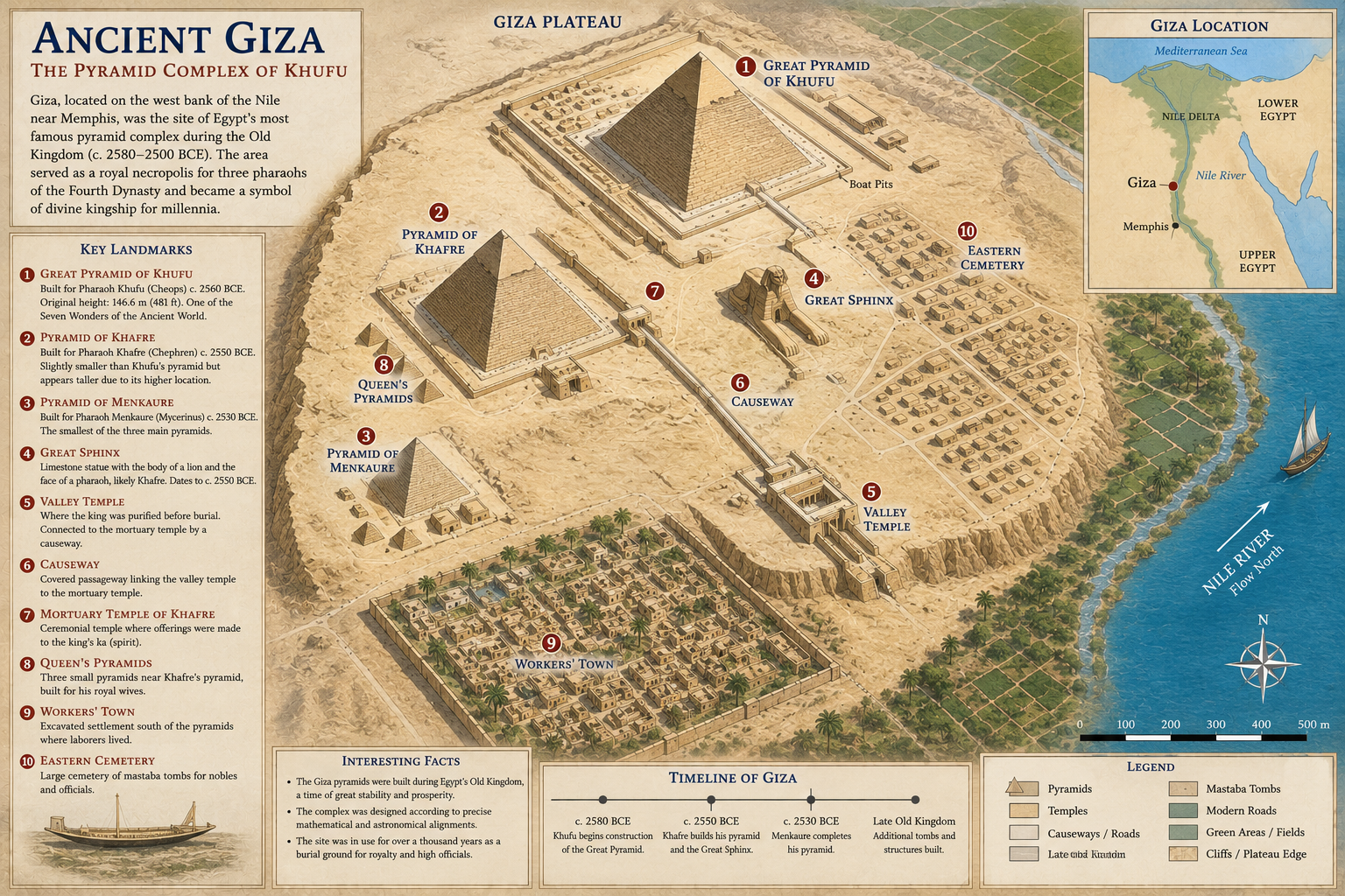
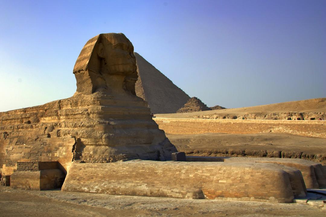
Giza is best known for the Great Pyramid, the Pyramid of Khafre, the Pyramid of Menkaure, and the Great Sphinx. Located on the west bank of the Nile near modern Cairo, Giza became the royal cemetery for several Old Kingdom pharaohs.
Although Giza was not a major city in the same way as Memphis or Thebes, it was one of the most important sacred landscapes in Ancient Egypt. The pyramid complexes, temples, causeways, workers’ settlements, and tombs of officials reveal the enormous organization required to build and maintain royal monuments.
Saqqara

Saqqara was the vast necropolis of Memphis and one of the longest-used burial grounds in Egyptian history. It is best known for the Step Pyramid of Djoser, designed during the Third Dynasty and often considered the earliest large-scale stone monument in Egypt.
The site contains pyramids, mastaba tombs, temples, animal burials, and underground galleries used across many periods of Egyptian history. Because Saqqara remained active for thousands of years, it provides an extraordinary record of changing Egyptian burial customs, architecture, and religious beliefs.
Heliopolis
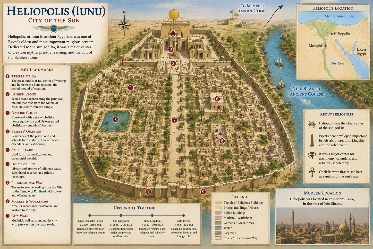
Heliopolis, known to the ancient Egyptians as Iunu, was one of the oldest and most important religious centers in Egypt. Located in Lower Egypt near modern Cairo, it was closely associated with the sun god Ra and the creation myths of ancient Egyptian religion.
Priests at Heliopolis developed influential religious ideas about creation, kingship, and the solar cycle. The city was especially connected with the benben stone, the sacred mound of creation, and the obelisk, a solar symbol that later became one of Egypt’s most recognizable monuments.
Elephantine
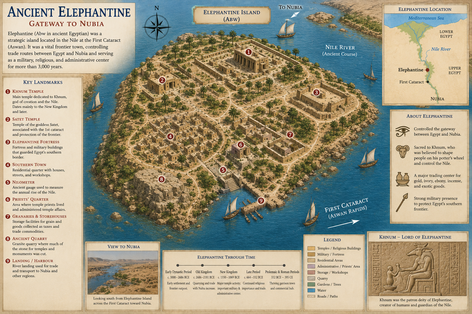
Elephantine was located on an island in the Nile near the First Cataract at Aswan. Because it stood near Egypt’s southern border, it served as an important military, trading, and administrative center.
The city controlled movement between Egypt and Nubia, making it vital for trade in gold, ivory, incense, ebony, and other luxury goods. Elephantine was also associated with the god Khnum, who was believed to shape human beings on a potter’s wheel and control the Nile’s life-giving waters.
Tanis
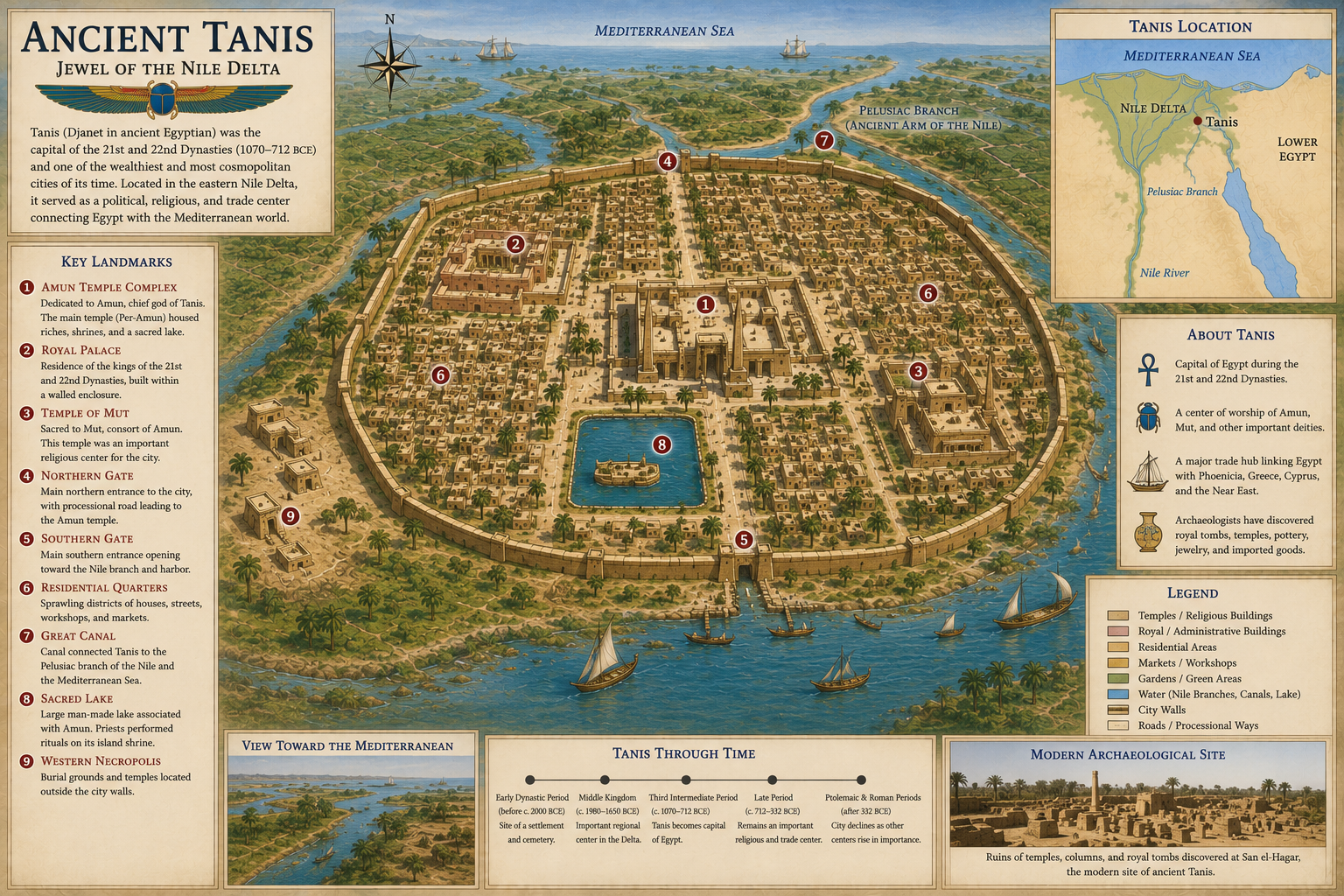
Tanis was an important city in the northeastern Nile Delta and became especially powerful during the Third Intermediate Period. It served as a royal capital during the 21st and 22nd Dynasties, when political power in Egypt was often divided between northern rulers in the Delta and religious authorities in Thebes.
The city contained temples, royal tombs, and monuments reused from earlier sites, including Pi-Ramesses. Tanis is sometimes called the “Thebes of the North” because of its religious and political importance during later Egyptian history.
Avaris
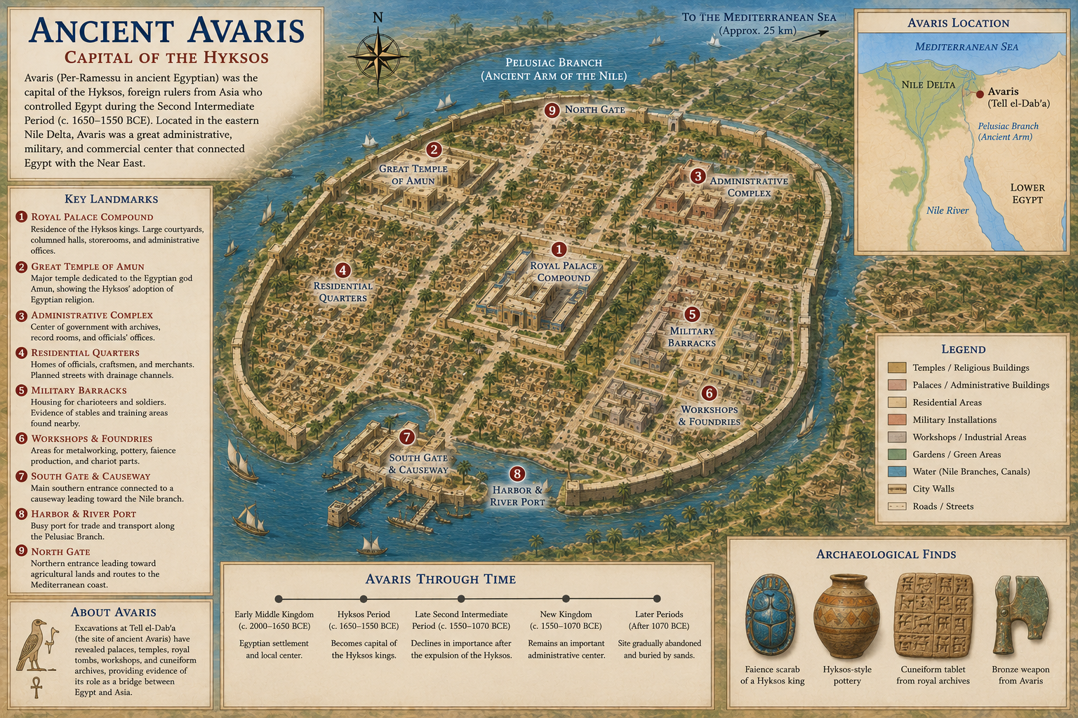
Avaris was located in the eastern Nile Delta and became the capital of the Hyksos rulers during the Second Intermediate Period. Its location made it a major gateway between Egypt and the Levant, allowing trade, migration, and foreign influence to flow into the Delta.
The city had strong connections with western Asia, and archaeology has revealed evidence of Near Eastern-style houses, burials, and material culture. After the Hyksos were driven out by rulers from Thebes, Avaris remained important and later influenced the development of Pi-Ramesses nearby.
Pi-Ramesses
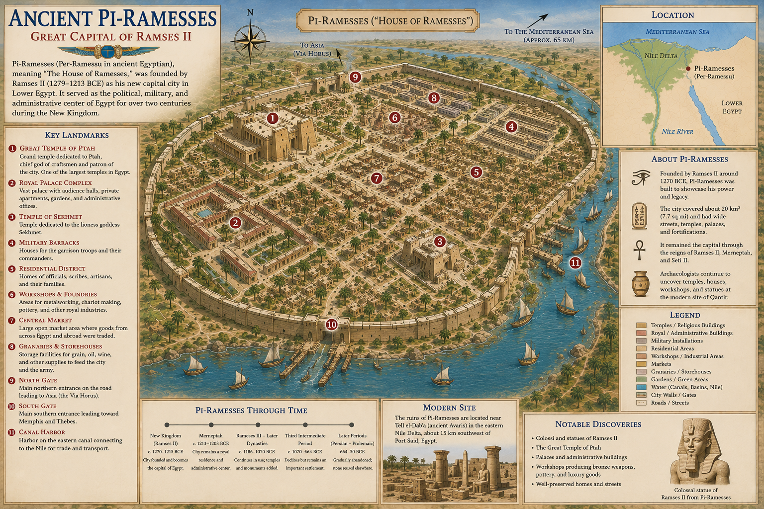
Pi-Ramesses was built by Ramesses II in the eastern Nile Delta as one of the greatest royal cities of the New Kingdom. Its location near older Avaris gave Egypt quick access to the Sinai, the Levant, and important military routes.
The city was filled with palaces, temples, military facilities, stables, workshops, and administrative buildings. During the reign of Ramesses II, Pi-Ramesses became a symbol of royal power and Egypt’s international influence. After the Nile branches shifted, much of the city was eventually abandoned, and many of its monuments were moved to Tanis.
Egypt Pyramid Map

The pyramids of Ancient Egypt are among the most recognizable monuments ever built, but they were never confined to a single location. Over a period of nearly 1,000 years, Egyptian kings constructed pyramids at dozens of sites stretching along the Nile Valley. While the Great Pyramids of Giza are the most famous, they represent only a small part of Egypt’s remarkable pyramid-building tradition.
The earliest royal pyramids appeared during the Third Dynasty with the construction of the Step Pyramid of Djoser at Saqqara. Designed by the architect Imhotep around 2670 BC, it was the world’s first monumental stone building and marked a revolutionary advance in architecture. During the Fourth Dynasty, pyramid construction reached its peak with the magnificent pyramids at Giza and Dahshur, where pharaohs such as Khufu, Khafre, Menkaure, and Sneferu commissioned some of the largest and most sophisticated monuments ever built.
As Egypt’s history progressed, pyramid construction evolved. Middle Kingdom rulers built pyramids at sites such as Lisht, Hawara, El-Lahun, and Dahshur, although these were generally smaller than their Old Kingdom predecessors. By the New Kingdom, pharaohs abandoned pyramid construction altogether in favor of hidden rock-cut tombs in the Valley of the Kings. However, pyramid-shaped monuments continued to influence Egyptian funerary architecture for centuries, and later rulers in Nubia revived the tradition by building hundreds of steep-sided pyramids at sites such as El-Kurru, Nuri, and Meroë.
Major Pyramid Sites
Giza is home to the Great Pyramid of Khufu, the Pyramid of Khafre, the Pyramid of Menkaure, the Great Sphinx, and numerous temples and mastaba tombs. Together, they form the world’s most famous pyramid complex and the last surviving Wonder of the Ancient World.
Saqqara served as the principal necropolis of Memphis for more than three millennia. Its monuments include the Step Pyramid of Djoser, the Pyramid of Unas, the Pyramid of Teti, the unfinished Pyramid of Sekhemkhet, and hundreds of mastaba tombs.
Dahshur was one of the most important royal pyramid fields of the Old Kingdom. Here, Pharaoh Sneferu experimented with pyramid design by constructing both the Bent Pyramid and the Red Pyramid, the latter generally regarded as Egypt’s first successful true pyramid.
Abu Rawash, north of Giza, contains the remains of the Pyramid of Djedefre, the son and successor of Khufu. Although heavily quarried in later centuries, it was once one of Egypt’s largest pyramid complexes.
Meidum preserves one of Egypt’s most unusual pyramids. Originally built as a step pyramid and later converted into a smooth-sided pyramid, much of its outer casing collapsed in antiquity, giving it its distinctive tower-like appearance.
Lisht, El-Lahun, and Hawara became important royal cemeteries during the Middle Kingdom. Their pyramids demonstrate how royal architecture changed over time while preserving many traditional religious concepts established centuries earlier.
Why Were Most Pyramids Built Along the Nile?
Nearly every royal pyramid stands within a few miles of the Nile River. This was no coincidence. The river provided the water, fertile farmland, transportation network, and workforce needed to construct these enormous monuments. Massive limestone and granite blocks could be floated to building sites on barges during the annual inundation, while nearby settlements housed the thousands of skilled workers, artisans, priests, and administrators who maintained the pyramid complexes.
The western side of the Nile also held deep religious significance. Because the sun set in the west each evening, Egyptians associated that direction with death, the afterlife, and rebirth. As a result, nearly all royal pyramid fields were established on the west bank of the Nile, where the deceased king symbolically joined the setting sun before being reborn each morning alongside the solar god Ra.
Today, archaeologists have identified more than 120 ancient pyramids across Egypt, ranging from the colossal monuments of Giza to the smaller brick pyramids of the Middle Kingdom. Together, these sites reveal nearly a millennium of innovation in engineering, royal ideology, and religious belief, making the pyramid fields one of the greatest archaeological landscapes on Earth.
