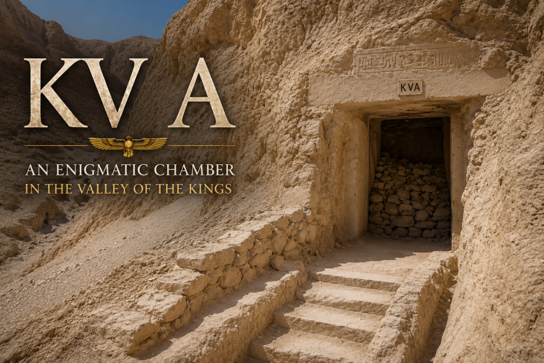
KV A
KV A is located in the main wadi of the West Valley and is cut into the base of a cliff at the head of a watercourse, approximately 60 meters (197 feet) south of the entrance to KV22, the tomb of Amenhotep III.
- Structure: KV A
- Location: West Valley, Thebes West Bank, Thebes
- Owner: Unknown
- Other Designations: WV A, WVA
- Site Type: Tomb or Storage Chamber
The monument consists of a short flight of rough-cut steps (A) descending to a gate (B), much of whose original rubble blocking survived intact during the site’s excavation. Beyond the entrance lies a single chamber (B), which was partially filled with limestone chips and accumulated debris.
Excavations uncovered numerous fragments of broken pottery vessels, including examples decorated in the distinctive blue-painted style of the Eighteenth Dynasty. Jar sealings and dockets bearing the name of Amenhotep III, dated to regnal years 32 and 37, were also discovered within the chamber. Additional finds included limestone ostraca containing sketches, ceramic palettes used for holding pigments, lumps of plaster, fragments of rope, scarabs, jewelry, and other materials associated with tomb construction and decoration.
Although designated as a tomb, there is no evidence that KV A ever served as a burial place. Instead, archaeological evidence suggests that the chamber was primarily used as a storage area, possibly during the construction and decoration of KV22, the nearby tomb of Amenhotep III. Some scholars have proposed that it may have functioned as a workman’s cache or temporary storeroom for equipment and burial goods.
Noteworthy Features
- Much of the original blocking of the entrance was discovered still in place, making KV A one of the few Valley of the Kings monuments to preserve substantial ancient sealing material.
- The site yielded numerous artifacts connected with the construction and decoration of KV22.
- Despite its designation as a tomb, no evidence of an actual burial has been found.
Axis
- Axis in degrees: 222.72
- Axis orientation: Southwest
Site Location
- Latitude: 25.44 N
- Longitude: 32.36 E
- Elevation: 178.01 m above sea level
- North: 99,623.449
- East: 93,564.798
- JOG map reference: NG 36-10
- Modern Governorate: Qena (Qina)
- Ancient Nome: Fourth Upper Egyptian Nome
- Surveyed by TMP: Yes
Measurements
- Maximum height: 2.42 m
- Minimum width: 1.71 m
- Maximum width: 4.86 m
- Total length: 9.64 m
- Total area: 28.53 m²
- Total volume: 42.14 m³
Additional Tomb Information
- Entrance location: Base of a sheer cliff
- Owner type: Unknown, probably non-royal
- Entrance type: Staircase
- Interior layout: Single chamber
- Axis type: Straight
Categories of Objects Recovered
- Cordage
- Jewelry
- Scarabs and seals
- Vessel stands
- Vessels
- Written documents
Interpretation
It remains uncertain whether the construction of KV A was contemporary with KV22 or whether it predates the reign of Amenhotep III. Based on the artifacts recovered from the debris, the chamber appears to have first served as a storage area for equipment used during the excavation and decoration of KV22.
Later, vessels and other objects associated with Amenhotep III’s burial equipment were stored in the chamber. Additional artifacts connected with the king’s burial, including part of a leather quiver, may have originated from debris removed from KV22 and subsequently deposited in KV A.
No evidence indicating that the chamber ever contained a burial has been discovered.
Dating: This site was used during the following period:
- New Kingdom, Dynasty 18, reign of Amenhotep III (c. 1390 to 1353 BCE), or possibly earlier.
Jar sealings and dockets bearing the name of Amenhotep III and dated to regnal years 32 and 37 indicate that the chamber was in use during the latter part of his reign. However, it remains uncertain whether the chamber was excavated specifically for Amenhotep III’s burial project or predated the construction of KV22 and was later reused as a storage facility.
History of Exploration
- Robert Hay (1825-1835): Visit
- Carl Richard Lepsius (1844-1845): Excavation
- Edward Russell Ayrton (1905): Excavation
- Émile Chassinat (1905-1906): Excavation
- Harry Burton (1912): Excavation
- Ernest Harold Jones (1912): Excavation
- Waseda University Expedition (1993-1994): Excavation
Conservation History
Following excavation and clearance of the monument, the surviving ancient blocking at the entrance was reinforced with additional rubble masonry to help stabilize and preserve the site.
Site Condition
A substantial portion of the original entrance blocking remains in place, providing valuable evidence for understanding ancient sealing practices in the Valley of the Kings.