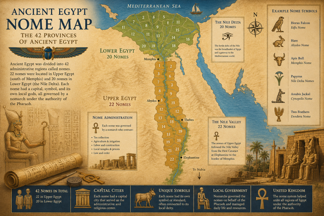
Ancient Egyptian Nome Map: The 42 Provinces of Ancient Egypt
Ancient Egypt was not only divided into Upper and Lower Egypt. It was also divided into smaller regions called nomes, which functioned much like provinces or districts. These nomes helped the pharaoh govern the country, collect taxes, organize agriculture, manage temples, and control local communities along the Nile.
The ancient Egyptian word for a nome was sepat, while the word “nome” comes from Greek. By the later periods of Egyptian history, the traditional system included 42 nomes: 22 nomes in Upper Egypt and 20 nomes in Lower Egypt.
A map of the Egyptian nomes helps show how carefully Ancient Egypt was organized. Each nome had its own capital city, local gods, religious symbols, administrative officials, and regional identity.
What Was a Nome in Ancient Egypt?
A nome was an administrative region of Ancient Egypt. Each nome covered a specific area of land, usually centered around part of the Nile Valley or the Nile Delta. These regions made it easier for the central government to manage a country that stretched hundreds of miles from Nubia in the south to the Mediterranean Sea in the north.
Each nome was governed by an official known as a nomarch, meaning the ruler or governor of a nome. The nomarch oversaw local administration, taxation, agricultural production, irrigation, labor, and temple affairs. In strong periods of Egyptian history, nomarchs served under the authority of the pharaoh. In weaker periods, some became powerful local rulers in their own right.
The 42 Nomes of Ancient Egypt
The traditional map of Ancient Egypt included 42 nomes in total. Upper Egypt had 22 nomes, arranged from south to north along the Nile Valley. Lower Egypt had 20 nomes, spread across the Nile Delta and the northern region of the country.
This division reflected Egypt’s geography. Upper Egypt was a long, narrow strip of fertile land along the Nile. Lower Egypt was broader and more complex because the river split into several branches before reaching the Mediterranean Sea.
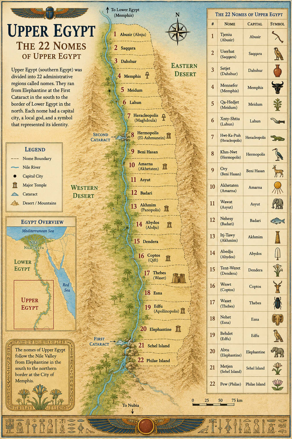
Upper Egyptian Nomes
Upper Egypt contained 22 nomes. These nomes began near the First Cataract at Elephantine and continued northward toward the region of Memphis. Important Upper Egyptian nomes included areas centered around Elephantine, Edfu, Thebes, Abydos, Dendera, Akhmim, Hermopolis, and Asyut.
Because Upper Egypt was mostly a narrow river valley, its nomes often followed the Nile in a fairly clear sequence. Many of Egypt’s most important religious centers were located here, including Thebes, Abydos, Edfu, and Dendera.
Thebes, ancient Waset, belonged to the fourth nome of Upper Egypt and became one of the greatest religious capitals in Egyptian history. Abydos became sacred to Osiris, while Edfu was associated with Horus. These local religious identities made each nome more than just an administrative district. Each one had its own sacred landscape.
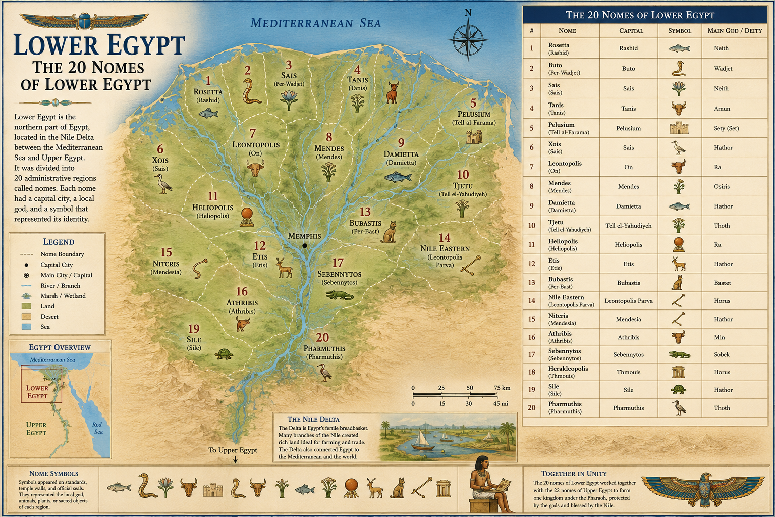
Lower Egyptian Nomes
Lower Egypt contained 20 nomes. These were located mainly in the Nile Delta, where the river divided into branches and flowed into the Mediterranean Sea. Important Lower Egyptian nomes included regions around Memphis, Sais, Buto, Xois, Heliopolis, Mendes, Bubastis, Tanis, and the eastern Delta.
The Delta was agriculturally rich and strategically important. It connected Egypt to the Mediterranean, Sinai, and the Levant. Because of this, Lower Egyptian nomes were especially important for trade, defense, diplomacy, and contact with foreign peoples.
Some Lower Egyptian capitals became extremely influential. Memphis was one of Egypt’s earliest political capitals. Sais became powerful during the Late Period. Heliopolis was one of the oldest centers of sun worship and was closely connected with the god Ra.
Nome Capitals
Each nome had a capital city or major administrative center. These capitals served as local hubs for government, religion, storage, taxation, and trade.
A nome capital usually contained temples, administrative buildings, granaries, workshops, markets, and residences for local officials. From these cities, scribes recorded harvests, officials collected taxes, and priests maintained the cults of local gods.
Some nome capitals remained important for thousands of years. Others rose and fell depending on changes in politics, trade routes, royal favor, or religious importance.
Nome Symbols and Standards
Each nome had its own symbol, often displayed on a standard. These symbols appeared in temple reliefs, processions, offering scenes, and religious artwork. They could represent animals, plants, sacred objects, local gods, or features associated with that region.
For example, some nomes were associated with animals such as the hare, the jackal, or the cow. Others used symbols connected to gods, weapons, trees, mountains, or ritual objects. These standards helped identify each region visually, much like flags or emblems identify places today.
Nome symbols were especially important in temple art. In many reliefs, personified nomes appear bringing offerings to the king or to the gods. This imagery showed that every region of Egypt contributed to the prosperity of the whole country.
How the Nome System Helped Egypt Function
The nome system was essential to Egyptian administration. Ancient Egypt depended on agriculture, and agriculture depended on careful control of the Nile flood, irrigation canals, grain storage, and labor. Dividing the country into nomes made these tasks easier to manage.
Local officials could monitor farmland, organize workers, collect grain taxes, maintain canals, and report back to the royal administration. Temples also played a major role in nome life, since they owned land, employed workers, stored goods, and served as religious and economic centers.
This system allowed Egypt to remain organized across a long and narrow landscape. Even though Egypt was ruled by a pharaoh, much of the daily work of government happened locally within the nomes.
Nomarchs: Governors of the Nomes
The governor of a nome was known as a nomarch. A nomarch was responsible for managing the region on behalf of the king. His duties could include tax collection, justice, irrigation, construction projects, temple support, military recruitment, and local security.
During strong dynasties, nomarchs were closely controlled by the central government. During periods of political weakness, however, nomarchs could become extremely powerful. In the First Intermediate Period, for example, local governors gained greater independence as central royal authority weakened.
This balance between royal power and local power was one of the most important political tensions in Ancient Egyptian history.
Why Nome Maps Matter
A nome map reveals a side of Ancient Egypt that is often overlooked. Most maps show famous cities, pyramids, temples, or tombs. A nome map shows how the civilization actually functioned.
The nomes explain how Egypt was governed, how taxes were collected, how local gods shaped regional identity, and how the pharaoh maintained control over such a long country. They also show that Ancient Egypt was not a single uniform culture. It was a collection of local communities bound together by the Nile, religion, administration, and kingship.
Ancient Egypt’s 42 Nomes at a Glance
The traditional system included:
- 22 nomes in Upper Egypt
- 20 nomes in Lower Egypt
- Each nome had a capital city
- Each nome had its own symbol or standard
- Each nome had local gods and religious traditions
- Each nome was governed by a nomarch
- The nome system helped manage taxes, agriculture, labor, temples, and local administration
The nomes were the building blocks of Ancient Egyptian government. They allowed the pharaohs to organize the country, manage local resources, and connect hundreds of towns and villages into one powerful civilization.
A map of the 42 nomes gives us a deeper understanding of Ancient Egypt than a simple map of cities or monuments. It shows the administrative skeleton of the kingdom: the districts, capitals, symbols, governors, and sacred regions that kept Egypt functioning for thousands of years.
Understanding the nomes helps explain how Ancient Egypt remained one of the most stable and long-lasting civilizations in the ancient world.
Share this:
- Share on Facebook (Opens in new window) Facebook
- Share on Pinterest (Opens in new window) Pinterest
- Share on X (Opens in new window) X
- Share on Telegram (Opens in new window) Telegram
- Share on WhatsApp (Opens in new window) WhatsApp
- Share on Reddit (Opens in new window) Reddit
- Share on LinkedIn (Opens in new window) LinkedIn
- Share on Tumblr (Opens in new window) Tumblr
- Print (Opens in new window) Print
